


We’ve waited all year for summer. Now that it’s finally here, kids and parents alike are bursting to get outside and soak up every second of sunshine.
In the mood for some outdoor adventure, but working with a shoestring budget? Try getting to know the conservation authorities located in Ottawa’s backyard!
They offer insightful educational programs and day camps, plus they maintain some of the most scenic areas in and around the city. Beaches, trails, picnic areas, boat launches and loads of outdoor fun await (and you don’t even have to break the bank for plane tickets to the Rockies or that overpriced cabin rental on the lake!).
What do conservation authorities do?
A conservation authority’s main purpose is to manage natural resources, primarily land and water, on a watershed basis. Ontario has 36 conservation authorities. They participate in many different activities, including:
- surveys and studies of natural resources
- education programs
- land use planning and forestry
- waterfront development
- fish, wildlife and forest management
- flood control, forecasting and warning
- water quality monitoring
- natural area and heritage conservation
What is a watershed?
A watershed is an area of land that drains to a common location. A watershed can vary in size, they can represent the area draining to a small stream to the entire area draining to an ocean. Everyone lives in a watershed. Do you know which watershed you live in?
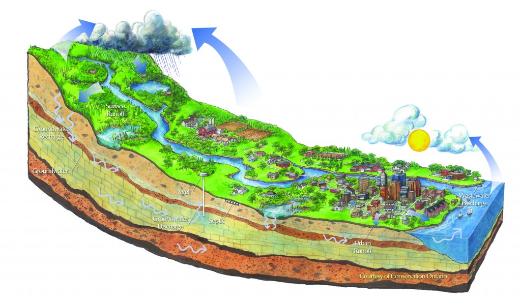
How many watersheds do we have in Ottawa?
In Ottawa, three watersheds meet: the Rideau, Mississippi, and South Nation. There’s a conservation authority that oversees each watershed:
Rideau Valley Conservation Authority (rvca.ca)
The watershed of the Rideau River drains an area of over 4,000 km² of Eastern Ontario. The main stem of the river flows in a northerly direction from Upper Rideau Lake near Newboro to the City of Ottawa, where it tumbles over Rideau Falls into the Ottawa River. The watershed includes well-known and well-loved towns such as Portland, Perth, Smiths Falls, Merrickville, Kemptville and Manotick. About 620,000 people live in the watershed, including a large part of the City of Ottawa.
Mississippi Valley Conservation Authority (mvc.on.ca)
Draining over 250 lakes and wetlands, the Mississippi River watershed encompasses an area of 3,750 km² from its headwaters at Mazinaw Lake to its confluence at the Ottawa River. Together with the drainage areas of the Carp River, MVCA has a total jurisdiction of 4,353 km².
South Nation Conservation Authority (nation.on.ca)
The South Nation River begins north of Brockville and empties into the Ottawa River near Plantagenet. All of the land drained by the river is called the South Nation Watershed, an area that includes 15 different municipalities. In some cases, watersheds will also include sub-watersheds, like the Hoasic Creek watershed in South Dundas, which flows into the St. Lawrence River. The jurisdiction covers 4,384 km2 of complex ecosystems.
Find your own fun at one of the many conservation areas!
The Rideau Valley Conservation Authority and the Mississippi Valley Conservation Authority maintain a number of areas that are perfect for a family day trip, full of sunshine and outdoor adventure. Make it a goal to check out a new spot this summer!
Mill of Kintail Conservation Area (mvc.on.ca/places-to-see/mill-of-kintail)
Spend a day hiking on an extensive trail system, situated on 62 hectares near Almonte. It is home to the Conservation Education Program and the popular Wildlife Watchers Day Camp.
Take in the restored grist mill museum featuring Dr. James Naismith, the inventor of basketball, and sculptor, physical educator and physician Dr. R. Tait McKenzie, both of whom were born and raised in Mississippi Mills.
Enjoy the picnic areas, historic chapel and a new, fully accessible playground and half basketball court. The Mill fee is $6/vehicle or $40 for a season pass.
Purdon Conservation Area (mvc.on.ca/places-to-see/purdon)
This unique wetland near Lanark is famous for being home to the largest native colony of Showy Lady’s Slipper Orchids in Canada. Each year between mid-June and early July, thousands of magnificent orchids burst into delicate pink-and-white bloom. Purdon exists today thanks to the care and cultivation of Joe Purdon. Stroll along the boardwalk or hike through an uplands forest.
Parking, washrooms and picnic areas are wheelchair-accessible. Admission is by donation.
Morris Island Conservation Area (mvc.on.ca/places-to-see/morris-island)
Located along the Ottawa River near Fitzroy Harbour, this 47-hectare site consists of forested woodlands and wetlands that will appeal to nature enthusiasts of all ages. Enjoy the best of Ontario’s summer weather by hiking, canoeing, kayaking, dog walking, jogging or fishing.
Wheelchair-accessible facilities include nature trails, fishing platforms, washrooms and picnic areas. Free parking; admission is by donation.
Chapman Mills Conservation Area (rvca.ca/careas/chapman)
Nestled in the heart of suburban Barrhaven, this roughly nine-hectare parcel of conservation land is perfect for a short nature walk with small children. Be sure to stop and read the interpretive signs along the 1.5-kilometre path, which includes bridges, boardwalks and a scenic view of the Rideau River. Pack a picnic lunch to enjoy under the shelter, and be on the lookout for the many ducks, frogs and other wildlife that call this conservation area home.
W.A. Taylor Conservation Area (rvca.ca/careas/wataylor)
W.A. Taylor is set along the beautiful Rideau River near Osgoode, and is one of the best spots to launch your boat or enjoy a quiet picnic with the family. The site of a couple of local fishing tournies, local hotspots have given up sporty bass, perch, pickerel, panfish and the occasional musky. Catch-and-release is encouraged.
The conservation area offers a boat launch and dock; fees apply for use of the boat launch.
Baxter Conservation Area (rvca.ca/careas/baxter)
Baxter consists of 68 hectares of mixed forest, tree plantations, open meadows, marsh and freshwater pond habitats. It also includes a sandy beach, picnic areas, a group campsite, a nut tree grove and wildflower gardens.
There are five kilometres of trails that will lead you through Baxter’s forest, marsh and meadow habitats. Exploring the trails will also take you along the scenic shoreline of the Rideau River.